Uruguay continues showing advances in the country’s Digital Agenda and in the D9 Group. On May 29th 2019, the President of the Republic’s office informed: “Uruguay will be the first country in the region to produce a digital and photographic model of its territory.” Video Uruguay Digital (Agesic, 2019)
The third International Conference on Spatial Data, authorities announced the possibility of obtaining digital images from the entire uruguayan territory in high quality and with digitally referenced information from the relevant entity, be it a Ministry, Agency or Departmental Government.
Uruguayan citizens and the rest of the world can access current information regarding a particular plot of land and state of the soil on that plot, as well as which social policies are being carried out in a certain suburban zone of Montevideo, the state of the highways in a particular region and where to find the Centers of Citizen Assistant or other entities that are involved in Plan Ceibal (one laptop per child in the elementary and high school) or Ibirapitá (digital inclusion of retired people).
On a Departmental (State) level, the GIS will allow the government to link the term budgets to the public works projects going on during that period and to the purchases and procurements. On a National level the focus will continue to be on centralizing and standardizing systems and cloud data storage so that it can be easily accessed and reused.
The Infrastructure of Spatial Data project (Infraestructura de Datos Espaciales de Uruguay IDE.uy) has been advancing on digitalizing geographic information, this being a critical pilar and cartographic in order to develop public policy and sustainable development initiatives that aim to generate what are called Smart Cities.
Based on a clear agency agenda and work guidelines (AGENDA IDE, Agosto, 2016), the AGESIC advanced in defining a workplan for between 2016 and 2020 so that the state institutions work on three basic and clear concentrations: Generating Geographic Information, Strengthening Hubs and Governance.
From the “hidden city” concept put forth by Latour to smart cities, we observe the way in which Countries are defining their strategies to reach greater environmental, sustainability as well as transparency and efficiency in public and private services.
In other words, Callon (1986), Latour (1986) define the above process using the theory of the Actor-Network (ANT), a constructivist focus whose activity consists in tying together heterogeneous elements during a determined period of time in which mechanisms of simplification and juxtaposition intervene (Castells, 1998). The result can be seen in the development of a digital territorial project that is the most integral and participative, eventually reaching co-production of public services on apps using open data.
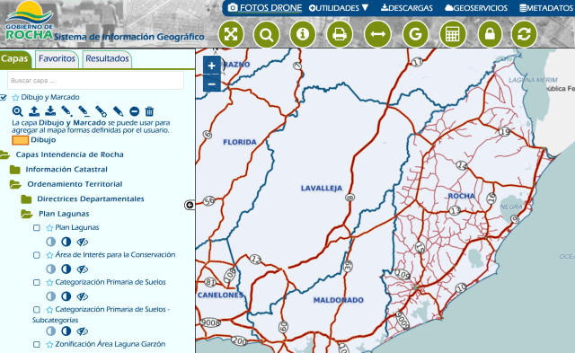
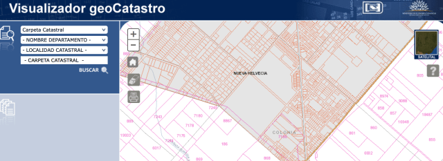
In the images presented it is clear how from the Departmental Government of Montevideo and other Departments it is possible to access a territorial image based on lot numbers. Additionally, accessing the IDEuy hubs, it is possible to identify which institutions are available in the geoPortal and geoServices. In this way it possible to access smart views for different layers of information or open data, thus complying with international standards.
Considering another case of best practices in digital government in Uruguay, there are elements that bring into question the possibility of seeing the future, planning for land ordinances, both in terms of the 5 year electoral period and digital convergence. This allows for these elements to be defined within a government plan so that the citizenry can openly and transparently follow the compliance of policies, both interveening and collaborating in a participative manner throughout the entire government term (Bieito, M. 2015).
Finally, in the images we can observe data treatment. The art and science of data today makes it possible to predict things that will happen and thus take corrective action before these things actually happen on the ground. In Mollytec.com we are responsible for and concerned about making sure that public and private business firms adopt these tools in a simple way and in accordance with the degree of digital maturity that the business has.
Uruguay avanza significativamente en el camino hacia las ciudades inteligentes
Uruguay continúa materializando avances en la Agenda Digital y en el grupo D9. El pasado 27 de mayo del 2019, la Presidencia de la República informó: “Uruguay será el primer país de la región en concretar un modelo digital y fotográfico sobre su territorio”. Video Uruguay Digital (Agesic, 2019)
En la 3.ª Jornada Internacional de Infraestructura de Datos Espaciales, se informa la posibilidad de contar con imágenes digitales de todo el territorio del Uruguay en alta calidad y con información referenciada según el organismo competente, léase un Ministerio, Ente o los Gobiernos Departamentales.
Los uruguayos y el resto del mundo pueden acceder a información referenciada sobre un padrón y el estado del suelo, qué políticas sociales se realizaron en la zona suburbana de Montevideo, cómo es el estado actual de las rutas y dónde se encuentran los Centros de Atención Ciudadana o aquellos vinculados con el plan Ceibal (una computadora por niño en escuelas y liceos) o Ibirapitá, programa especializado en la inclusión digital del adulto mayor.
Desde lo departamental el Sistema de Información Geográfica (GIS) permitirá unir los presupuestos quinquenales con las obras realizadas y los expedientes vinculados con las compras y licitaciones generando transparencia y rendición de cuentas de manera participativa. En lo Nacional continuar la línea de la centralización y estandarización de sistemas y datos en la nube para el beneficio de su reutilización, generando ahorros significativos entre otros beneficios.
Con la Infraestructura de Datos Espaciales de Uruguay (IDE.uy), se viene avanzando en la digitalizacón de la información geográfica, siendo éste un pilar cartográfico fundamental, para desde allí almacenar las políticas y desarrollos sostenibles que se pretende generar con las llamadas Ciudades Inteligentes.
Por medio de una agenda y líneas de trabajo (AGENDA IDE, Agosto, 2016), se procedió a definir un cronograma trazado entre el 2016 y el 2020 (se venía concientizando y trabajando hace más de una década), para que las instituciones del estado trabajen sobre tres líneas bien concretas: Generación de Información Geográfica, Fortalecimiento de Nodos y Gobernanza.
Desde la ciudad escondidada de Latour (París), hasta las ciudades inteligentes, encontramos la definición del progreso territorial y cómo los países definen sus estrategias para lograr una mayor sustentabilidad con el ambiente, transparencia y eficiencia en los servicios públicos y privados.
En otras palabras, Callon (1986), Latour (1986) definen lo anterior como la teoría del actor-red (ANT), un enfoque constructivista, cuya actividad consiste en entrelazar elementos heterogéneos durante un cierto período de tiempo, donde intervienen mecanismos de simplificación y yuxtaposición (Castells, 1998). El restulado pasa por desarrollar un proyecto territorial digital lo más integral y participativo posible, hasta llegar a la co-producción de servicios públicos en apps con datos abiertos.
En las imágenes apreciamos como desde el Gobierno Departamental de Montevideo y otros departamentos podemos tener acceso a una foto territorial por padrones. También accediendo a los nodos IDEuy, identificamos qué insitituciones cuentan desde el geoPortal hasta los geoServicios, pudiendo acceder a vizualizadores inteligentes por diferentes capas de información o datos abiertos, cumpliendo estándares internacionales.
Visualizamos otro caso de estudio de buenas prácticas en gobierno digital del Uruguay. Encontramos elementos que nos permiten cuestionar la posibilidad de ver en el futuro, planes de ordenamiento territorial, quinquenales y digitales convergentes, definidos dentro de un programa de gobierno para que la ciudadana pueda de manera transparente y abierta, seguir el cumplimiento de las políticas, interviniendo y colaborando de manera participativa a lo largo de cada período de gobierno. (Bieito, M. 2015).
Por último vemos en las imágenes el tratamiento de los datos. El arte de la ciencia de datos, hoy permite predecir hechos, tomar acciones correctivas antes de que sucedan en el territorio. Conocer de dónde salen y hacia dónde van las exportaciones en un territorio dado. En Mollytec.com nos ocupamos y preocupamos para que las empresas públicas y privadas adopten éstas herramientas de manera simple y según el grado de maduración digital que poseen.
Marcelo Bieito, Ph.D. Septiembre, 2019.
Contacto: info@marcelobieito.com +598 99520119


Fuentes :
21/09/2019
Fuente:
Links:
Territory Innovation

The Architecture of Change: Building a Better World

The Architecture of Changeis a collection of articles that demonstrates the power of the human spirit to transform the environments in which we live. This inspiring book profiles people who refused to accept that things couldn’t change, who saw the possibility of making something better and didn’t hesitate to act. Breaking down the stereotypes surrounding «socially engaged architecture,» this book shows who can actually impact the lives of communities. Like Bernard Rudofsky’s seminal Architecture Without Architects: A Short Introduction to Non-Pedigreed Architecture, it explores communal architecture produced not by specialists but by people, drawing on their common lives and experiences, who have a unique insight into their particular needs and environments. Running through their stories is a constant theme of social justice as an underlying principle of the built environment. This book is about opening one’s eyes to new ways of interpreting the world, and how to go about changing it.
Editorial Reviews Review «Collectively, the articles [in The Architecture of Change] convey the message that ordinary people, young and old, despite obstacles (mainly poverty), can effectively design neighborhoods, build houses and playgrounds, and in other ways shape sustainable communities.» —Choice «The cumulative weight of the volume goes beyond the anecdotal and episodic to create a rich picture of the theory, history, and practice of grassroots activism. . . . The book, in addition to being informative and provocative, is a pleasure to read.» —Progressive Planning «The Architecture of Changeis a must-read. . . . Reminding people about the need for systemic change and the belief that change is possible when those affected lead is the legacy that The Architecture of Changecelebrates.» —The Architect’s Newspaper About the Author Jerilou Hammett and Kingsley Hammett cofounded DESIGNER/builder: A Journal of the Human Environment. Together they wrote The Essence of Santa Fe: From a Way of Life to a Styleand coedited The Suburbanization of New York: Is the World’s Greatest City Becoming Just Another Town?


The Essence of Santa Fe: From a Way of Life to a Style
The Essence of Santa Fe: From a Way of Life to a Style traces the developments that took a unique and sustainable way of life and turned it into style. Through a rich blend of historic and contemporary photographs, the book unveils the undeniable magic of this charming city that still can be found if one knows where to look.
Suburbanization of New York
The city that never sleeps also never stops changing. And while New Yorkers are renowned for their trendsetting, this thought-provoking book argues that New York City itself has become a follower rather than a leader. Once-distinctive streets and neighborhoods have become awash in generic stores, apartment boxes, and garish signs and billboards. Legendary neighborhoods (Little Italy, Hell’s Kitchen, Harlem, the Lower East Side) have been smoothed over with cute monikers, remade for real-estate investment and for sale to the highest bidder. What does the future hold for the legendary metropolis, gateway to immigrants and strivers, magnet for builders and dealers, muse for artists and dreamers? Will the current political, economic, and social influences dull its once-famous creative edge and culture of opposition? What will become of the special allure of New York? The Suburbanization of New Yorkpresents fourteen timely, provocative articles that explore the radical transformation unfolding in New York City and raise serious questions about the future of any metropolis struggling to maintain its unique identity. It is essential reading for anyone interested in the field of urban studies or the forces shaping our cities today.
About the Author
Kingsley Hammett has been working as a journalist since 1979 and is publisher of DESIGNER/builder magazine. He holds a master’s degree in both journalism and humanities/history. Kingsley is the author of three books on New Mexican furniture: Crafting New Mexican Furniture, Classic New Mexican Furniture, and Early New Mexican Furniture. He has lived in Santa Fe, with his wife Jerilou, for nearly twenty-five years. Jerilou Hammett holds master’s degrees in education and humanities. She is co-founder of Designer/builder magazine and has been active in the civic life of Santa Fe for more than twenty-five years. Peter Scholz is currently a freelance graphic designer living in Colorado. He spent thirteen years in Santa Fe as co-owner of a design firm


Comments